
- in European Union
- in European Union
- within Criminal Law, Finance and Banking and Intellectual Property topic(s)
This post provides a brief overview of the draft National Geospatial Policy, 2021 released recently by the Department of Science and Technology of the Indian government, and discusses our comments on the draft policy.
In early May 2021, the Department of Science and Technology ("DST") released a draft National Geospatial Policy ("draft NGP") for comments. The draft NGP aims to boost geospatial entrepreneurship for the socio-economic development of India, promote the use of geospatial products and services, generate useful insights from geospatial data and strengthen India's geospatial infrastructure and capabilities. Our comments to the draft NGP are captured briefly in this post. Our actual comments sent to the DST can be accessed here.
Geospatial data guidelines liberalizing use of geospatial data:
Before releasing the draft NGP, the DST liberalized the access to and use of geospatial data through its guidelines to acquire and produce geospatial data ("Geospatial Guidelines")1. The Geospatial Guidelines shifted the regulatory landscape from licensing requirements to access geospatial data, to allowing companies to access geospatial data based on its accuracy thresholds. The Geospatial Guidelines have significantly improved access to geospatial data for private sector companies in India. This will help boost innovation in the geospatial technologies industry. The Geospatial Guidelines will also include a yet-to-be-defined negative list of attributes which companies cannot capture while mapping or accessing geospatial data. We have written a detailed blogpost on the Geospatial Guidelines.
Overview of the draft NGP:
The draft NGP is the logical next step in the new geospatial regulatory landscape. It provides a framework for the DST and its partnering agencies at the state and central level (e.g., government departments, regulatory authorities, etc.) to enable access to geospatial data and promote its use. Some of its key measures include:
1. Committee to shape geospatial data ecosystem in India: A multi-disciplinary expert committee called the Geospatial Data Promotion and Development Committee ("GDPDC") will replace the existing National Spatial Data Committee.2 It will be tasked with working with the Survey of India to create a High Resolution National Topographic Database3 and will create "Lead Agencies" at the central and state level.4
2. Establishment of data sets: These Lead Agencies will provide sector specific knowledge and assist in the compilation of data themes under the National Foundation Geospatial Data Asset and the National Thematic Geospatial Data Asset.5
3. Standards for data sets, National Data Registry and Geo-platform: The Lead Agencies will also lead and facilitate the implementation of the draft NGP. This will include examining the Foundation and Thematic Data Asset data sets and identifying challenges, or suggesting standards for their metadata or data use, storage, creation, and processing.6 A National Data Registry will be operated by the GDPDC, to enable access to and harnessing of geospatial data.7 State and central level partnering agencies can provide data through Data Nodes.8 The geospatial data, metadata, and data from the State/central level agencies will be available through a Geo-Platform.9 The GDPDC will designate a Partnering Agency to develop and operate the NDR and Geo-platform under its guidance and supervision on matters of their scope, functionality, and performance.10
4. Skilled workforce: The draft NGP calls for the registration of Surveyors to promote the profession of surveying, with professional standards and accreditation akin to what medical and legal professionals have.11 Additionally, it proposes the National Skill Development Council and the geospatial industry to work together to compile a National Skills Qualification Framework, and ultimately develop a Geospatial Sector Skill Council.12
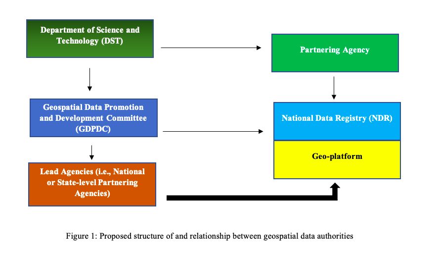
Figure 1: Proposed structure of and relationship between geospatial data authorities
Our comments on the draft NGP:
In our comments we highlight the following issues as either needing greater clarity or as issues that need to be considered before any implementation:
1.Geospatial data and NPD framework: Proprietary geospatial data should not be made part of the mandatory data sharing process of high-value datasets as proposed in the NPD framework.
2. International standards for geospatial data management: The government should adopt internationally accepted standards of geospatial data management and handling, instead of developing new domestic standards.
3. Geospatial data and the Personal Data Protection Bill, 2019: The draft NGP must delve into the privacy implications of geospatial data collected in the context of the Personal Data Protection Bill, 2019. Geospatial data may qualify as personal data in certain situations, and thus attract additional obligations for private companies and government alike.
4. Federal implementation of draft NGP: The draft NGP must be implemented in a federal manner i.e. at both the central and state level. Some of the areas where geospatial data may be useful could fall under the State List of the Constitution. Thus, the relationship between the central and state governments in developing and managing access to the National Data Registry and Geo-platform should be made clearer.
5. Accounting for ISRO's role in geospatial data management: ISRO should be closely consulted in the drafting and implementation of a geospatial policy as there may be overlaps.
6. Fast-track approval for drones used to map geospatial data: The draft NGP should include a separate section on the importance of drones for the geospatial data sector. For certain sectors involving drone mapping like agriculture and health, the DST can work with the Ministry of Civil Aviation to create a fast track approval process under the recently notified drone rules.
7. Ensuring stakeholder consultations for key decisions: The GDPDC should consult with stakeholders before making decisions like restricting disclosure of geospatial data.
Footnotes
1. Guidelines for acquiring and producing Geospatial Data and Geospatial Data services including Maps, https://dst.gov.in/sites/default/files/Final%20Approved%20Guidelines%20on%20Geospatial%20Data.pdf
2. Para 10.2.1., of the draft NGP, 2021.
3. Para 7.1.2., of the draft NGP, 2021.
4. Para 7.4.2., of the draft NGP, 2021.
5. Para 7.4.1. of the draft NGP, 2021.
6. Para 7.4.2.3., of the draft NGP, 2021.
7. Para 7.6.1., of the draft NGP, 2021.
8. Para 7.6.2., of the draft NGP, 2021.
9. Para 7.6.2., of the draft NGP, 2021.
10. Para 7.6.3., of the draft NGP, 2021.
11. Para 6.2., of the draft NGP, 2021.
12. Para 6.1.3., of the draft NGP, 2021.
The content of this article is intended to provide a general guide to the subject matter. Specialist advice should be sought about your specific circumstances.