
Last week, the Bureau of Ocean Energy Management (BOEM) announced progress on its long-term plan to lease areas for critical mineral1 development on the Outer Continental Shelf (OCS).2
First, on Nov. 10, 2025, BOEM published an Area Identification (Area ID) for potential commercial leasing for critical minerals offshore American Samoa. Next, on November 12th, it published a Request for Information and Interest for commercial leasing for critical minerals offshore the Commonwealth of the Northern Mariana Islands (CNMI). These announcements further the administration's objectives to prioritize U.S. leadership in seabed mapping and mineral exploration to ensure reliable access to critical minerals set forth in President Trump's Executive Order 14285, "Unleashing America's Offshore Critical Minerals and Resources."3 EO 14285 is aimed at fast-tracking deep-sea mining to "reinvigorate American leadership in associated extraction and processing technologies, and ensure secure supply chains for our defense, infrastructure, and energy sectors."
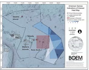
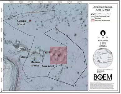
Area Identification Offshore American Samoa
BOEM commenced the leasing process for critical minerals offshore American Samoa on June 16, 2025, with a Request for Information and Interest (RFI).4 The RFI was published in response to an April 8, 2025, unsolicited request for a lease sale and centers around the area located near the eastern limit of the American Samoa OCS bordering the Cook Islands Exclusive Economic Zone, northeast of Manu'a Island and Rose Atoll. The RFI comprised approximately 18.1 million acres with approximate water depths ranging from 4,600–20,000 feet.
On June 23, 2025, following a meeting of the government leaders regarding the RFI, the government of American Samoa expressed unified opposition to the proposed leasing and its continued support of a July 2024 executive order issued by the governor imposing a moratorium on "any mining, extracting, removing, or any exploration activities related to the mining, extracting, or removing of minerals from the seabed in waters of American Samoa." At the request of the American Samoa government, the public comment period was extended for 30 days.
As detailed in the Area ID memorandum, multiple industry groups expressed interest in the leasing process offshore American Samoa in response to the RFI. Polymetallic nodules deposits were identified by industry groups as their primary target for commercial development due to their potential to contain commercially viable quantities of cobalt, nickel, copper, manganese, zinc, rare earth elements, and other minerals that may prove economically viable to extract and process in the future.
BOEM considered available OCS mineral resources, environmental data, and information and interest when considering whether to proceed with additional steps leading to a potential OCS mineral lease sale.5 More than 1000 unique comments (more than 70,000 total) were submitted with a wide range of support and concerns, including from government officials, industry, indigenous communities, and environmental groups. BOEM summarized the key comments and themes in the Area ID memorandum as outlined below.
Of particular importance is the objection posted by the American Samoa Governor Pulaali'i Nikolao Pula who, according to the Area ID memorandum, again communicated the "territory's opposition to commercial leasing in the EEZ, urged full consideration of the territorial moratorium on seabed mining, requested that no activity proceed without territorial consent, and emphasized environmental, scientific, and equitable consultation concerns." Given BOEM continues to move forward with its process along the way to leasing and the lack of discussion in the Area ID memorandum regarding those concerns, it is unclear to what extent these objections ultimately will be considered.
Other comments on the RFI raised the following issues.
- Environmental concerns (e.g., impacts on marine ecosystems, fisheries, biodiversity, sediment plumes, food webs, etc.).
- Cultural concerns (waters hold deep cultural significance for Pacific Islanders, traditional use areas, and underwater cultural heritage).
- Socioeconomic concerns (e.g., reliance of territory on tuna fishing/processing and employment/food security).
- Requests for meaningful consultation with Indigenous communities and incorporation of revenue‐sharing with local communities.
- Input on lease structure: royalty rates, rental payments, auction formats, lease size, clause for contraction, etc.
- Concerns that deep‐sea mining in the area is economically and technically uncertain due to mineral price volatility, emerging alternatives/recycling, lack of U.S. processing/supply chain, and other factors.
After considering the information and comments provided, BOEM announced on November 12th that it had identified an area for potential commercial leasing comprised of approximately 6,069 whole and partial blocks covering approximately 33,136,060 acres no closer than 50 miles to the American Samoa islands, Rose Atoll, and Swains Island.6 As set forth in the Area ID memorandum, the final area includes all available blocks within the RFI Area plus an additional contiguous area to the southwest that extends to the southern boundary of the EEZ. Ultimately, the recommended area is approximately 15,000,000 acres larger than the RFI Area.
The next step in BOEM's leasing process is to conduct an environmental analysis in advance of a lease sale. The information received in response to the RFI and available environmental analysis will inform the environmental review of preliminary activities permissible under a lease7 needed to prepare plans for comprehensive technical and environmental review by BOEM and to inform future project-specific analysis if BOEM issues leases and lessees submit plans under those leases.
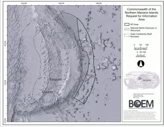
Request for Information and Interest – CNMI
The RFI for commercial leasing offshore the CNMI is the first step in BOEM's regulatory process that could ultimately lead to a commercial lease sale. Next will be an area identification similar to that completed for American Samoa, a proposed leasing notice, which will include an environmental analysis, a leasing notice, and then a lease sale. The RFI Area is located west of the Mariana Trench National Monument along the eastern edge of the U.S. Exclusive Economic Zone (Northern Mariana Islands). This area is approximately 35,483,044 acres with an approximate water depth of 3,700-25,100 feet and includes 6,502 whole or partial OCS lease blocks. The RFI Area includes an area consisting of abyssal plain, seamounts, and guyots and is within a marine mineral prospective region for ferromanganese crust and nodules, as identified by the USGS.8
BOEM requests information on:
- Which OCS minerals (single/multiple/all) to lease and where.
- Geologic, archaeological, or seabed hazard data.
- Other ocean uses (shipping, navigation, recreation, etc.).
- Environmental, biological, socio-economic data; mining impacts, and mitigation information.
- Information about commercial, Indigenous, and recreational fisheries, area use, gear types, timing, and conflict-avoidance input.
- Environmental sensitivity and marine productivity data.
- Preliminary activity needs (survey, testing, and equipment).
- Expected delineation, testing or mining of OCS minerals.
- Consistency with CNMI's Coastal Zone Management Program.
- Indigenous cultural and ancestral site information.
- Community socio-economic impacts and engagement ideas.
- Considerations for deep-water OCS development: depth, seafloor conditions, operations, extraction feasibility, and cost.
- Fair rental rate structure (initial and later years).
- Royalty rate options balancing incentives and public return.
- Bid deposits, minimum bids, and auction format preferences.
- Appropriate lease size offshore CNMI.
- Lease duration, contraction timing, and scale suggestions.
- Alternate valuation methods for royalty calculation.
BOEM invites respondents to identify and map specific blocks or areas within the RFI Area that they wish to nominate for potential inclusion in an OCS mineral lease sale. For each nominated area, respondents should provide:
- The specific area proposed for leasing;
- The OCS minerals of primary interest;
- Any available information on OCS mineral resources, geological and archaeological characteristics, and environmental conditions relevant to the proposed area—including methods to avoid, minimize, or monitor potential impacts.
In accordance with Section 304 of the National Historic Preservation Act (NHPA), BOEM must withhold information about the location, character, or ownership of historic resources if disclosure could risk harm to those resources or interfere with access to traditional religious sites.9 Indigenous peoples, communities, and organizations are encouraged to clearly identify any information they submit that should be treated as confidential under Section 304.
BOEM must receive all comments, information, and indications of interest in response to this RFI no later than December 12, 2025.10 Comments and information should be submitted electronically through http://www.regulations.gov using the docket number BOEM-2025-0351 or by mail to: Bureau of Ocean Energy Management, Pacific Region, Office of Strategic Resources, 760 Paseo Camarillo (CM 102), Camarillo, California 93010.
Indications of interest in commercial leasing should not be submitted in the Federal Register but instead electronically via email to Pacific.Region@boem.gov or by hard copy by mail to the following address: Bureau of Ocean Energy Management, Pacific Region, Office of Strategic Resources, 760 Paseo Camarillo (CM 102), Camarillo, California 93010.
Conclusion
Executive Order 14285 initiated an aggressive use of U.S. authorities to extract critical minerals from the seabed. The Executive Order, BOEM's actions, and pending rulemaking by NOAA represent a shift in U.S. foreign and domestic policy towards the development of a competitive regime for permitting exploitation of deep-sea mineral deposits.
Footnotes
1.Critical minerals are defined as any minerals, elements, substances, or materials that are determined to be essential to the economic and national security of the United States, have a supply chain vulnerable to disruption, and play an essential role in manufacturing a product whose absence would significantly affect U.S. economic or national security. The U.S. Geological Survey issued its Final List of Critical Minerals on November 7, 2025. Section 7002 of the Energy Act of 2020 (Pub. L. No. 116-260, Division Z).
2.The Outer Continental Shelf Lands Act (OCSLA) governs mineral exploration and development on the OCS. Section 50251(b) of the Inflation Reduction Act of 2022 expanded the definition of the OCS under the OCS Lands Act to include submerged lands within the Exclusive Economic Zone adjacent to U.S. territories and amended the OCS Lands Act by modifying the definition of "State" to include each of the 50 States of the Union, the Commonwealth of Puerto Rico, Guam, American Samoa, U.S. Virgin Islands, and the CNMI. BOEM administers mineral leasing on the OCS. Section 8(k) of the OCS Lands Act authorizes the Secretary of the Interior to grant leases on the OCS to qualified persons offering the highest cash bonuses for minerals other than oil, gas, and sulfur on a competitive basis. 43 USC 1337(k). Under BOEM's existing regulations, any person, entity, or company can request that OCS marine minerals be offered for lease. 30 CFR § 581.11. The first step in the process for issuing a commercial lease is the issuance of an RFI under 30 CFR 585.12(a).
3.As detailed in our recent update, these two announcements complement NOAA's development of a proposed rule to streamline the permitting process for deep-sea mining.
4.Note that according to a June 25, 2025, press release, U.S. Department of the Interior stated that its policies to expedite critical mineral development would "include earlier identification of potential areas on the OCS for development right away, without first issuing a formal request for information or forming a joint task force with state and federal agencies." BOEM, however, states the contrary on its websites for both American Samoa and CNMI, which include issuance of an RFI in its regulatory pathway for OCS Minerals Leasing. See here and here.
5.The recommended area is consistent with prospective
seabed mineral regions identified by the U.S. Geological Survey
(USGS) in and around the RFI Area for ferromanganese crusts and
polymetallic nodules. See USGS Coastal and Marine Hazards
and Resources Program. Global Marine Mineral Prospective Regions
Map.
January 31, 2025. https://www.usgs.gov/media/images/global-marine-mineral-prospective-regions-map.
6.This decision was consistent with the request of Congresswoman Radewagen in comments.
7.These types of surveys include bathymetric, geological, geophysical, and other surveys that are necessary to develop a comprehensive Delineation, Testing, or Mining Plan required under 30 CFR 582.21(d).
8.bsp;See above at n. 3.
9.See RFI section 8 (c).
10. Any confidential business information to be included in the submission must be marked as such. See RFI section 8 (a).
The content of this article is intended to provide a general guide to the subject matter. Specialist advice should be sought about your specific circumstances.
[View Source]