

- within Intellectual Property topic(s)
- in European Union
- within Privacy topic(s)
- in European Union
The invention relates to improving agricultural field management. This was achieved by running clustering algorithm with different parameters to generate multiple zone layouts and planting plans, from which the user can select. The Board considered that while it may enhance the grower's flexibility, it has no technical effect as it appears to be driven by administrative or economic considerations. Since neither the claim nor the application specifies how the management zone delineation options and planting plans are used to control the equipment, merely "using" these options and plans for control does not alter their abstract nature.
Here are the practical takeaways from the decision: T 1717/22 (Management zones in agricultural fields/CLIMATE LLC) of May 16, 2025 of the Technical Board of Appeal 3.5.01
Key takeaways
While a feature may enhance the grower's flexibility, it has no technical effect. Instead, the provision of multiple options appears to be driven by administrative or economic considerations.
The steps for determining the management zone delineation options and the planting plans define a data processing algorithm. Algorithms contribute to the technical character of an invention only if they serve a technical purpose.
The provision of planting plans is not a technical purpose since these plans may be based on non-technical economic considerations, such as maximising the grower's profits.
A method serving no technical purpose cannot become technical merely because it processes technical data or is executed on a computer. This is because non-technical, e.g. business or administrative, methods also exploit information about the physical world and can be automated, yet their fundamental nature remains non-technical.
While controlling agricultural equipment is a technical process, merely "using" these options and plans for control does not alter their abstract nature. Hence, the general aim of controlling equipment cannot impart a technical character to the determination of the management zone delineation options and planting plans.
Generating and displaying a graphical representation of the planting plans is not technical as it relates to the presentation of information. It only serves to inform the user about the planting plans, which is a cognitive effect rather than a technical one.
Choosing and customising planting plans are not necessarily technical tasks.
The invention
The Board defined the invention as follows:
1.1 The invention aims at improving agricultural field management through data-driven techniques (see paragraph [0002] of the published application).
The main idea is to divide an agricultural field into contiguous regions with similar characteristics, known as "management zones", and to provide tailored farming recommendations ("planting plans" in claim 1) for each zone (see, e.g. [0004], [0005]).
1.2 Concretely, the computer-implemented method in claim 1 determines multiple "management zone delineation options" that represent different ways of dividing the field into management zones. Each option is obtained by clustering yield and field characteristic data (e.g. soil and topology characteristics, [0130]) using a "count value" for "a management class count". The claim does not define the count values or their role in the clustering, but the description vaguely suggests that each count value defines the number of clusters ([0192]).
After determining the management zone delineation options, the method proceeds to provide one or more planting plans for selected options (see Figures 13 and 14 and paragraphs [0240] to [0251] for examples). The management zone options and planting plans are presented to the user and are used to control seeding, irrigation, fertilisation or harvesting equipment.
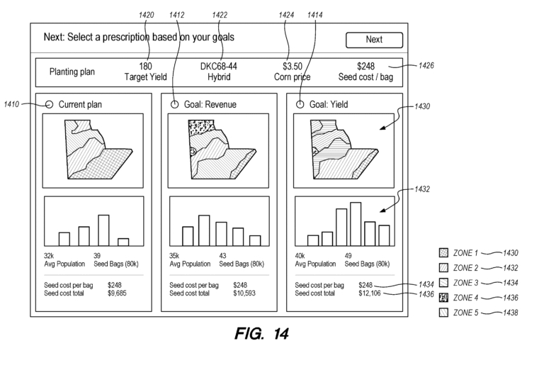
Fig.14 of WO 2018/093931 A1
Claim 1 of the Main Request
A method comprising:
using instructions programmed in a computer system comprising one or more processors and computer memory:
receiving yield data representing yields of crops that have been harvested from an agricultural field, and field characteristics data representing one or more characteristics of the agricultural field;
using the instructions programmed in the computer system, determining a plurality of management zone delineation options, wherein each option, of the plurality of management zone delineation options, comprises zone layout digital data for an option, wherein the plurality of management delineation options is determined by: determining a plurality of count values for a management class count; for each count value, of the plurality of count values, generating a management delineation option by clustering, using a count value of the plurality of count values, the yield data and the field characteristics data, assigning zones to clusters, and including the management zone delineation option in the plurality of management delineation options;
using the instructions programmed in the computer system, receiving one or more selection criteria; and based on, at least in part, the one or more selection criteria, selecting one or more options from the plurality of management zone delineation options, and determining one or more planting plans for each of the one or more options;
using a presentation layer of the computer system, generating and causing displaying on a computing device a graphical representation of the one or more options of the plurality of management zone delineation options and a graphical representation of the one or more planting plans associated with the one or more options;
using one or more options of the plurality of management zone delineation options and one or more planting plans to control agricultural equipment to be directed to follow the recommended planting plans in terms of seeding, irrigating, applying fertilizers, and/or harvesting.
Is it patentable?
The Examining division alleged that the non-technical features were implemented into a known system and thus were obvious over D1:
2.3 D1, like the current invention, deals with the determination of management zones for precision farming (see the abstract). The number of management zones is given by the user (column 4, lines 35 to 40), and their determination involves applying a self-organising map on yield and field characteristics data (Figures 5 and 6 and column 4 line 55 to column 5, line 7). The determined zones are displayed and used to create "prescription maps" (column 6, lines 4 to 7 and 14 to 18), which can be used to control farming equipment such as tractors, spreaders or planters for seeding and applying fertilisers and herbicides (column 1, line 62 to column 2, line 2).
The Board considers that using a self-organising map to derive management zones is a form of clustering as it groups related data (see, e.g. column 1, lines 58 to 62, column 2, lines 18 to 21, Figures 5 and 6; and D7). Furthermore, the number of management zones in D1 corresponds to a "count value", in the language of claim 1, and the prescription maps correspond to the planting plans (see also [0244] of the application).
The distinguishing features were identified as follows:
2.4 Hence, the method in claim 1 differs in that:
i) the management zone determination is carried out multiple times using different "count values" to obtain a plurality of management zone delineation options, one or more of these options are selected, and planting plans are determined for all selected options
ii) a graphical representation of the planting plans is generated and displayed
However, the Board agreed with the Examining Division that it was not technical :
2.6.1 The clustering in claim 1 is defined broadly and is indistinguishable from the clustering in D1. The main distinction is that in claim 1, the clustering process is repeated with different "count values", each specifying a different number of clusters. This results in multiple sets of management zones ("management zone delineation options"), each with corresponding planting plans.
Feature i) thus merely repeats a known process multiple times for the sole purpose of providing the grower with a number of alternative planting options to choose from. While this may enhance the grower's flexibility, it has no technical effect. Instead, the provision of multiple options appears to be driven by administrative or economic considerations (see e.g. [0251] and [0252] of the application).
The Applicant argued the following:
2.6.2 The appellant argued that the determination of management zone delineation options and planting plans were technical steps, essentially because they were:
1) based on technical data (yield and field characteristics data)
2) carried out by a computer system
3) used to control agricultural equipment
However, the Board was not convinced:
2.6.3 As set out below, the Board is not convinced.
The steps for determining the management zone delineation options and the planting plans define a data processing algorithm. Algorithms contribute to the technical character of an invention only if they serve a technical purpose (see G 1/19, point 112). However, the Board does not consider the provision of planting plans to be a technical purpose since these plans may be based on non-technical economic considerations, such as maximising the grower's profits (see [0246] and [0251]). Contrary to the appellant's view, the technical purpose of improving crop yield cannot be derived from the broad wording of claim 1.
A method serving no technical purpose cannot become technical merely because it processes technical data or is executed on a computer. This is because non-technical, e.g. business or administrative, methods also exploit information about the physical world and can be automated, yet their fundamental nature remains non-technical (see, e.g. T 154/04 – Estimating sales activity/DUNS LICENSING, point 20; T 0677/09 – Smart manual/CONTINENTAL AUTOMOTIVE SYSTEMS, point 8; T 2626/18 – Insurance risk prediction/SWISS RE, points 4.8 and 4.10.).
Furthermore, while controlling agricultural equipment is a technical process, neither the claim nor the application specifies how the management zone delineation options and planting plans are used to control the equipment. Merely "using" these options and plans for control does not alter their abstract nature. Hence, the general aim of controlling equipment cannot impart a technical character to the determination of the management zone delineation options and planting plans (see also page 5, third paragraph of the decision).
2.6.4 The appellant further argued that the management zones were technical quantities of the agricultural field and their determination was a technical process similar to example 4 in section G-VII 5.4.2.4 of the Guidelines for Examination (2022 version). This example relates to a computer-implemented method that controls an infrared camera to capture an image of the temperature distribution on a building's surface and then calculates the risk of condensation based on the air temperature and relative humidity. The appellant argued that predicting areas of increased risk of condensation was comparable to predicting management zones.
The Board does not consider this example to be relevant because the areas with increased risk of condensation reflect the physical state of the building. In contrast, the management zone delineation options are conceptual subdivisions created for practical management purposes, rather than inherent properties of the agricultural field that reflect its physical state. These zones are based on data-driven analysis and user-defined parameters (e.g. the number of clusters), which may vary depending on the user and their objectives.
The Board then discussed second distinguishing feature:
2.7 Re ii)
2.7.1 The Board is of the opinion that generating and displaying a graphical representation of the planting plans is not technical as it relates to the presentation of information. It only serves to inform the user about the planting plans, which is a cognitive effect rather than a technical one.
2.7.2 The appellant argued that this feature contributed to the technical character of the invention since it credibly assisted the user in performing a technical task by means of a continued and/or guided human-machine interaction process. In particular, it enabled the user to customise or decide on the planting plans.
The Board is not convinced for the simple reason that claim 1 does not specify any use of the displayed information. Moreover, the Board considers that choosing and customising planting plans are not necessarily technical tasks (see also point 2.6.3 above).
Therefore, the Board considered the subject-matter obvious:
2.8 In summary, the Board considers that features i) and ii) are non-technical and do not contribute to the technical character of the invention either individually or in combination. Hence, under the COMVIK approach, these features are incorporated into the objective technical problem as given requirements that the skilled person must implement. The Board finds that the claimed implementation is obvious as it amounts to a straightforward automation.
More information
You can read the full decision here:T 1717/22 (Management zones in agricultural fields/CLIMATE LLC) of May 16, 2025 of the Technical Board of Appeal 3.5.01
The content of this article is intended to provide a general guide to the subject matter. Specialist advice should be sought about your specific circumstances.
