During the 2008 Mumbai attacks the terrorists were believed to have utilized online mapping applications to plan and implement their attacks. There have also been instances of disputes with neighbouring countries on boundaries. In early 2016, the terrorist attacks on the Pathankot airbase gave rise to further security concerns in the country. Taking note of the same, the Government of India has proposed the Geospatial Information Regulation Act, 2016 ("Proposed Act"). The Proposed Act is mainly to regulate the acquisition, dissemination, publication and distribution of geospatial information of India which could affect the security, sovereignty and integrity of India.
The objective of the Proposed Act is not intended to prohibit services providing geospatial data but to regulate these for several reasons including securing the country's strategic installations.
SALIENT FEATURES OF THE PROPOSED ACT
The Proposed Act ‐
- seeks to define Geospatial Information to mean geospatial imagery or data acquired through space or aerial platforms such as satellite, aircrafts, balloons or graphical or digital data depicting natural or man‐made physical features, phenomenon or boundaries of the earth or any related information including surveys, charts, maps, terrestrial photos referenced to a co‐ordinate system and having attributes;
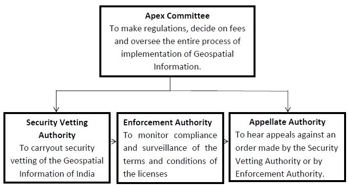
- envisages the creation of a Security Vetting Authority which will be empowered to carryout security vetting of the Geospatial Information of India;
- prohibits acquisition of Geospatial Information unless permission of a Security Vetting Authority for retention of such information is obtained;
- requires persons who have already acquired Geospatial Information to make an application to the Security Vetting Authority for retention of such information and grant a license for the same;
- prohibits dissemination, publication or distribution of Geospatial Information other than in accordance with the Proposed Act;
- requires that the permission of the Government or, in this case, a Security Vetting Authority is obtained for any addition or creation of anything that has to do with any Geospatial Information or location within the territory of India.
VARIOUS ENFORECEMNET AGENCIES UNDER THE PROPOSED ACT
PENALTIES UNDER THE PROPOSED ACT
- Stringent penalties are proposed in the Proposed Act for contraventions in respect of Geospatial Information including a fine of minimum of ten lakh rupees upto one hundred crore and imprisonment up to seven years.
DISPOSAL OF DATA BY UNLICENSED PERSONS
- Once the Proposed Act is enforced no person will be able to possess Geospatial Information of India, after rejection of the application by the Security Vetting Authority or after dismissal of appeal, if any, by the Appellate Authority or the High Court or the Supreme Court, as the case may be.
EXCLUSION OF COURTS TO HAVE JURISDICTION
- No Courts will have jurisdiction to entertain any suit or proceeding in respect of any matter which an Appellate Authority constituted under the Proposed Act will be empowered to determine and no Court will be able to grant an injunction in respect of any action taken in pursuance the Proposed Act.
OUR VIEWS
- No doubt India needs a Geospatial Information Act, but it has to be a contemporary statute which makes for faster and better implementation of intended policies, not a castigatory Act as the proposed one.
- The definition of Geospatial Information is so wide that it includes everything from satellite imagery, to atlases, books, magazines, car navigation systems etc; GPS enabled devices like cameras, smartphones and tablets. This would mean that an individual is also required to obtain a license for retention and use of the Geospatial Information. The Proposed Act effectively seeks to cover all aspects related to Geospatial Information including collecting, retaining, disseminating and publishing the same and seeks to extend the regulatory ambit to passive users of Geospatial Information such as individuals.
- The other issue is of dissemination and publishing Geospatial Information which is forbidden in physical and electronic forms. So does one need to seek a license from the Government to publish such Information? The answer to this under the Proposed Act would be in affirmative.
- What happens to the Government project like Digital India? . This Proposed Act envisages the involvement of industry to take up much of the work. With the Proposed Act in place there will have to be a licensing of these industries and the personnel working on these projects which will have to be vetted by the Security Vetting Authority. However, the Proposed Act does make a provision to exclude by notification exemption to certain bodies associated to the Central and State Governments.
- A lot of big companies have slammed the Proposed Act by saying that the bureaucracy may increase and an approval would be required for everything from the Government. This approval may create hindrances in business and development for companies and also at a micro level for the use of such Geospatial Information.
- While a certain degree of control is required over the capture, use, access dissemination of Geospatial Information (since such information is highly sensitive in nature); a balance is required to be achieved in the exercise of such control. Hence, a pragmatic view ought to be taken in the manner in which the Proposed Act would be finally enacted and implemented.
- Comments have been invited by the Government on the Proposed Act from the general public and although only time will tell as to the form in which the Proposed Act will be enacted, the current provisions of the Proposed Act seem like they will have far reaching implications not only on giants like Google, Apple and cab aggregators which function entirely on the basis of locations and maps.
The content of this article is intended to provide a general guide to the subject matter. Specialist advice should be sought about your specific circumstances.